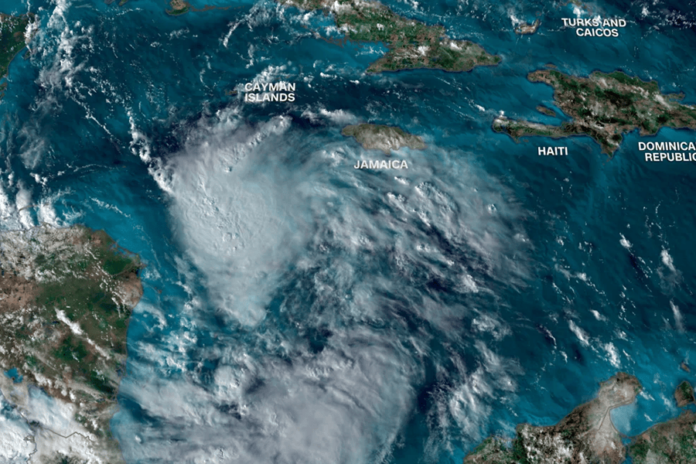
Tropical Storm Sara is on its way to the Caribbean and could bring some serious problems to parts of Central America as it heads toward the Gulf of Mexico.
The folks at the National Hurricane Center are advising everyone along the eastern Gulf Coast, especially in Florida, to keep a close eye on updates because there’s a chance this storm could make its way to the U.S. next week.
It’s just another twist in an Atlantic hurricane season that seems to be breaking all the usual patterns. Normally, we’d expect things to calm down by November, but here we are with our third named storm this month, thanks in part to those unusually warm waters linked to climate change.
Right now, it’s called Tropical Depression Nineteen and has maximum sustained winds of 35 mph. It’s sitting about 90 miles off the Honduras-Nicaragua border in the Caribbean Sea.
As it drifts and nearly stalls over those warm waters—similar conditions that powered Hurricane Rafael—it’s likely going to strengthen and could reach near-hurricane status near Honduras this weekend.
Hurricane and tropical storm warnings have already been issued for parts of Honduras and Nicaragua since wind and rain from Sara are expected to hit by Thursday evening and intensify on Friday.
The National Hurricane Center is warning that Honduras could see life-threatening flooding with rainfall totals reaching up to 30 inches, while other areas in Central America may also experience significant rain leading to dangerous flash floods and mudslides.
Looking ahead, Belize and the Yucatán Peninsula should prepare for strong storm surges and damaging winds early next week.
Residents there should start getting their hurricane plans ready! As for what might happen in Florida, Cuba, or around the eastern Gulf of Mexico? Well, that remains a bit of a mystery right now—forecasts can vary quite a bit once you get past Central America.
A lot will depend on how close Sara gets to land over the coming days; currently, predictions suggest it will hug Honduras’ coast without moving much inland over the weekend—but keep in mind that these forecasts can change!
Is the US a potential danger?
There are a few different possibilities regarding how strong the storm might get and whether it could hit the US next week.
One option is that it could make landfall in Honduras or Nicaragua this weekend and weaken as it moves over land, away from the warm waters that fuel it. In this case, Central America would experience powerful winds and heavy rain, but the storm might stay clear of the US.
Alternatively, if the storm stays really close to Central America without making landfall, it could still bring significant rainfall there and might eventually drift into the southern Gulf of Mexico next week.
If that happens, it would likely be weaker by then, which could lessen its impact if it does reach the US.
However, if the system hangs just a little further offshore over very warm water, we could see some serious strengthening and rapid intensification while it stalls out.
Right now, sea surface temperatures in the Caribbean are at their second-highest levels ever recorded—just behind this year’s record-breaking heat—which means they’re warmer than usual for peak hurricane season.
This warmth can create stronger storms that intensify quickly because of climate change driven by fossil fuel emissions.
From there, we might see a gradual turn to the northwest toward Mexico’s Yucatán Peninsula or Cuba before possibly entering the eastern Gulf of Mexico. The Gulf is exceptionally warm for this time of year too, which could help sustain or even boost any storm that gets into those waters.
This scenario would lead to severe flooding and damaging winds across Honduras, Nicaragua, and nearby areas for several days before moving away early next week. Depending on how strong it gets and how sharply it turns, Mexico’s Yucatán Peninsula or Cuba might face similar impacts next.
This situation is particularly concerning for us here in the US because a stronger system in the Gulf could aim straight for Florida next week.
So far this year, five hurricanes have struck along the US Gulf Coast! If this system were to make landfall here as well, it could break records; currently held by Hurricane Kate which hit Florida as a Category 2 on November 21st back in 1985.
Even though hurricane season officially wraps up on November 30th each year—there have been instances where named storms formed in December before!

